Rendering GeoJSON
Before getting into editing, we'll take a look at basic feature rendering with a vector source and layer. The workshop includes a countries.json GeoJSON file in the data directory. We'll start by just loading that data up and rendering it on a map.
First, edit your index.html in order to add a dark background to the map:
<!DOCTYPE html>
<html>
  <head>
    <meta charset="utf-8">
    <title>OpenLayers</title>
    <style>
      @import "node_modules/ol/ol.css";
    </style>
    <style>
      html, body, #map-container {
        margin: 0;
        height: 100%;
        width: 100%;
        font-family: sans-serif;
        background-color: #04041b;
      }
    </style>
  </head>
  <body>
    <div id="map-container"></div>
    <script src="./main.js" type="module"></script>
  </body>
</html>
Now we'll import the three important ingredients for working with vector data:
- a format for reading and writing serialized data (GeoJSON in this case)
- a vector source for fetching the data and managing a spatial index of features
- a vector layer for rendering the features on the map
Update your main.js to load and render a local file containing GeoJSON features:
import GeoJSON from 'ol/format/GeoJSON';
import Map from 'ol/Map';
import VectorLayer from 'ol/layer/Vector';
import VectorSource from 'ol/source/Vector';
import View from 'ol/View';

// assign to a variable named `map` for later use
const map = new Map({
  target: 'map-container',
  layers: [
    new VectorLayer({
      source: new VectorSource({
        format: new GeoJSON(),
        url: './data/countries.json',
      }),
    }),
  ],
  view: new View({
    center: [0, 0],
    zoom: 2,
  }),
});
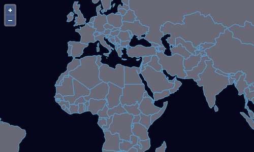
You should now be able to see a map with country borders at http://localhost:5173/.

Since we'll be reloading the page a lot, it would be nice if the map stayed where we left it in a reload. We can bring in the Link interaction to make this work.
In our main.js we'll import the new interaction:
import Link from 'ol/interaction/Link';
And now we can add a new link interaction to our map:
map.addInteraction(new Link());
Now you should see that page reloads keep the map view stable. And the back button works as you might expect.